- Registriert
- 17. Juli 2011
- Beiträge
- 11.129
- Reaktionspunkte
- 11.757
- Punkte
- 1.073
National Geographic World Atlas

Diese App wurde sowohl für das iPhone als auch für das iPad konzipiert
Kategorie: Referenz
Aktualisiert: 13.09.2013
Version: 3.3
Größe: 215 MB
Sprache: Englisch
Entwickler: National Geographic Society
© National Geographic Society
Kompatibilität: Erfordert iOS 5.0 oder neuer. Kompatibel mit iPhone, iPad und iPod touch. Diese App ist für iPhone 5 optimiert.
Beschreibung
The National Geographic World Atlas brings you the highest resolution map images available, delivering the stunning detail, accuracy, and beauty National Geographic is known for.
ALL MAPS IN HD
• All National Geographic maps are in HD for retina-displays, giving you the best viewing experience possible.
• New infographics enhance each country's Flags and Facts section.
• Better measurement tools give you even more accuracy.
NEW FEATURES
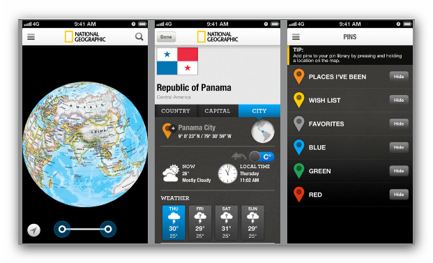
• Store your pins in the cloud and share them across devices. Plan a trip on your iPad, then use your customized map on your iPhone.
• Add and customize collections of map pins
• Get up-to-the-minute weather
• Check the latest currency conversion rates, or use the currency calculator to convert from one currency to another
• See latitude and longitude indications directly, with a tap of your finger.
THE LOOK
See the world in any style you prefer: classic (blue ocean), antique, satellite, or road map style (provided by Bing maps).
THE GLOBE
Spin, pan, and zoom in on the world with our interactive 3-D globe and seamless world map layers. Place pins to mark spots and save them for later.
FLAGS AND FACTS
Get up-to-date information on every country and capital city in the world, including socio-economic data, demographics, weather, and currency.
**All maps, pins, and latitude-longitude coordinates are for reference-use only, and are not meant for navigational use.


[HIDE]
Diese App wurde sowohl für das iPhone als auch für das iPad konzipiert
Kategorie: Referenz
Aktualisiert: 13.09.2013
Version: 3.3
Größe: 215 MB
Sprache: Englisch
Entwickler: National Geographic Society
© National Geographic Society
Kompatibilität: Erfordert iOS 5.0 oder neuer. Kompatibel mit iPhone, iPad und iPod touch. Diese App ist für iPhone 5 optimiert.
Du musst dich
Anmelden
oder
Registrieren
um diesen link zusehen!
Beschreibung
The National Geographic World Atlas brings you the highest resolution map images available, delivering the stunning detail, accuracy, and beauty National Geographic is known for.
ALL MAPS IN HD
• All National Geographic maps are in HD for retina-displays, giving you the best viewing experience possible.
• New infographics enhance each country's Flags and Facts section.
• Better measurement tools give you even more accuracy.
NEW FEATURES
• Store your pins in the cloud and share them across devices. Plan a trip on your iPad, then use your customized map on your iPhone.
• Add and customize collections of map pins
• Get up-to-the-minute weather
• Check the latest currency conversion rates, or use the currency calculator to convert from one currency to another
• See latitude and longitude indications directly, with a tap of your finger.
THE LOOK
See the world in any style you prefer: classic (blue ocean), antique, satellite, or road map style (provided by Bing maps).
THE GLOBE
Spin, pan, and zoom in on the world with our interactive 3-D globe and seamless world map layers. Place pins to mark spots and save them for later.
FLAGS AND FACTS
Get up-to-date information on every country and capital city in the world, including socio-economic data, demographics, weather, and currency.
**All maps, pins, and latitude-longitude coordinates are for reference-use only, and are not meant for navigational use.
[HIDE]
Du musst dich
Anmelden
oder
Registrieren
um diesen link zusehen!
[/HIDE]