- Registriert
- 17. Juli 2011
- Beiträge
- 11.172
- Reaktionspunkte
- 11.831
- Punkte
- 1.073
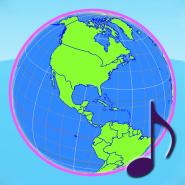
Globe Earth 3D Pro: Flags Anthems and World Time Zones
Diese App wurde sowohl für das iPhone als auch für das iPad konzipiert
Kategorie: Bildung
Aktualisiert: 15.03.2015
Version: 3.7
Größe: 47.3 MB
Sprachen: Deutsch, Englisch, Französisch, Griechisch, Italienisch, Japanisch, Koreanisch, Niederländisch, Polnisch, Portugiesisch, Russisch, Spanisch, Thai, Tradit. Chinesisch, Vereinf. Chinesisch
Entwickler: Chien-Yuan Chen
© 2013 Macbear
Kompatibilität: Erfordert iOS 5.1.1 oder neuer. Kompatibel mit iPhone, iPad und iPod touch. Diese App ist für iPhone 5 optimiert.

telefonbuch
Beschreibung

3D Globe with 249 countries (by ISO 3166-1) and 50 states of USA. Gesture control to browse the earth.
Double-taps to link to Wikipedia, and choose realistic flags. Play national anthems.
◎ Support Languages: 正體中文, English, 简体中文, 中文(香港), 日本語, Français, Español, Deutsch, Русский, Português, Italiano, Nederlands, Polski, Ελληνικά, 한국어, ภาษาไทย; Area(km²), Capital City, 首都城市.
◎ Display both names with different languages, and adjust font size
----------------
◉ Gesture Control ◉
◎ Tap: focus to center
◎ Double-Taps: link to Wikipedia, or choose flags
◎ Pinch: zoom in/out, rotate
◎ Slide: move viewer
◎ rotate-north-up toggle
----------------
◉ Feature ◉
◎ World time zone map (with sea, ocean)
◎ 2 High quality texture-maps, 1 animated-map for 3D earth
◎ 300 Realistic flags by real-time rendering
◎ 220+ national anthems (need to download from internet)
◎ Custom your own anthems(.mp3) in Documents folder via iTunes
◎ Support iOS device with retina display
◎ Support Landscape and Portrait mode
◎ Boundary, name, and flag info (by ISO 3166-1 with 249 countries)
◎ Disputed areas by red-outline
◎ Included ISO 3166-1 alpha-2, alpha-3 code
◎ Included 50 states of USA, United Nations, European Unions, and some geopolitical entities
◎ Longitude/Latitude display (with equator, tropical, and polar)
◎ Smoothly control by gesture: tap, double-taps, pinch, slide
◎ Search tool by name
◎ Show your location on earth
◎ Offline browse is OK. (except to link to Wikipedia)
IMG Removed
IMG Removed
Diese App wurde sowohl für das iPhone als auch für das iPad konzipiert
Kategorie: Bildung
Aktualisiert: 15.03.2015
Version: 3.7
Größe: 47.3 MB
Sprachen: Deutsch, Englisch, Französisch, Griechisch, Italienisch, Japanisch, Koreanisch, Niederländisch, Polnisch, Portugiesisch, Russisch, Spanisch, Thai, Tradit. Chinesisch, Vereinf. Chinesisch
Entwickler: Chien-Yuan Chen
© 2013 Macbear
Kompatibilität: Erfordert iOS 5.1.1 oder neuer. Kompatibel mit iPhone, iPad und iPod touch. Diese App ist für iPhone 5 optimiert.
telefonbuch
Du musst dich
Anmelden
oder
Registrieren
um diesen link zusehen!
Beschreibung
3D Globe with 249 countries (by ISO 3166-1) and 50 states of USA. Gesture control to browse the earth.
Double-taps to link to Wikipedia, and choose realistic flags. Play national anthems.
◎ Support Languages: 正體中文, English, 简体中文, 中文(香港), 日本語, Français, Español, Deutsch, Русский, Português, Italiano, Nederlands, Polski, Ελληνικά, 한국어, ภาษาไทย; Area(km²), Capital City, 首都城市.
◎ Display both names with different languages, and adjust font size
----------------
◉ Gesture Control ◉
◎ Tap: focus to center
◎ Double-Taps: link to Wikipedia, or choose flags
◎ Pinch: zoom in/out, rotate
◎ Slide: move viewer
◎ rotate-north-up toggle
----------------
◉ Feature ◉
◎ World time zone map (with sea, ocean)
◎ 2 High quality texture-maps, 1 animated-map for 3D earth
◎ 300 Realistic flags by real-time rendering
◎ 220+ national anthems (need to download from internet)
◎ Custom your own anthems(.mp3) in Documents folder via iTunes
◎ Support iOS device with retina display
◎ Support Landscape and Portrait mode
◎ Boundary, name, and flag info (by ISO 3166-1 with 249 countries)
◎ Disputed areas by red-outline
◎ Included ISO 3166-1 alpha-2, alpha-3 code
◎ Included 50 states of USA, United Nations, European Unions, and some geopolitical entities
◎ Longitude/Latitude display (with equator, tropical, and polar)
◎ Smoothly control by gesture: tap, double-taps, pinch, slide
◎ Search tool by name
◎ Show your location on earth
◎ Offline browse is OK. (except to link to Wikipedia)
IMG Removed
IMG Removed
Du musst dich
Anmelden
oder
Registrieren
um diesen Inhalt sichtbar zu machen!
IMG Removed